|
Issued: 0530hrs Monday 4th May 2026
Duty forecaster: Dan Graves
 A cold front slips into northern Scotland, brining showers and colder temperatures. Mixed cloud and sun elsewhere, well-scattered light showers, though a greater risk of showers southwest. A cold front slips into northern Scotland, brining showers and colder temperatures. Mixed cloud and sun elsewhere, well-scattered light showers, though a greater risk of showers southwest.
Good morning,
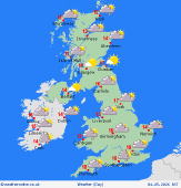
The murky, cloudy weather of days prior is beginning to make its exit today as a northerly flow establishes. Sunshine begins breaking out in Ireland and Much of England and Wales, and perhaps southern Scotland for several hours. Sun will be slow to arrive in the southwest of England and Wales where showers will linger, which could be heavy in the Pembroke and Cornwall peninsulas - the frontal systems that brought all the rain to prior days are trying to hold on for just a bit longer here!
Through afternoon, a cold front will slip into the north of Scotland, brining frequent showery rain and a notable drop in temperature. However, this front will only intrude as far south as the central Highlands during daylight. Thus, the day remains mild for many, highs to 18C in the far south, most seeing 14 to 15C.
The northerly flow will push the southern fronts out of the day, easing the showers in the southwest and brining a mix of cloud and clear skies overnight for Ireland and most of Britain from the Scottish Central Belt southward. A few small features may just bring a light sprinkling to the southwest and around the Humber. However, this cold front in Scotland continues to push southward, drawing showers across the Highlands and in the later hours reaching southeast Scotland as well as northern parts of Ireland. Lows at 8 to 10C southern England, 5 to 7C to the north and in Ireland, with frosts developing in northern Scotland.
Enjoy the day!
-Dan
Talk live to our forecasters for the latest forecast.
Call 0906 515 1506 (Calls charged at £1.55p/min from within the UK only, network charges may apply, service operated by WCS Ltd WV5 9JD, helpline 01902 895252)
|
