UK Forecast- July 01, 2025
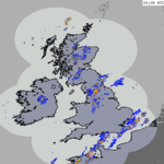
Heavy showers south today.
Scattered showers west.
 Wednesday
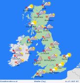
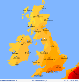
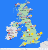
Southeastern England may see a few morning showersâ�'some possibly heavyâ�'but these will clear by early afternoon. Elsewhere, expect bright spells and scattered showers, particularly heavy across Northern Ireland, northern Scotland, and northeast England. A cooler day overall, with highs of 24°C in the south and 16°C in the north.
 Wednesday Night
All showers, away from the far northern parts of Scotland, will clear through the evening. Overnight mostly dry conditions for England and Wales, while increasingly cloud for Ireland Scotland with some showers in far western counties. Minimum temperatures at 17C in south but 10C in north.
 Thursday
A dry and sunny day is expected across England, Wales, and eastern Scotland. Scattered showers are expected over Ireland and western Scotland, especially over the northern and western counties, some of which may be heavy. Highs of 25°C in the south and around 15°C in the north.
 Friday
A fine and sunny start for England and Wales, turning increasingly cloudy during the afternoon. Ireland and Scotland will be mostly cloudy with outbreaks of rain, becoming more persistent and heavy, especially in western counties. Some rain for northwestern England and north Wales later in the day. Afternoon highs will reach 27°C in the south and 17°C in the north.
|